By Ken Lloyd Gruffydd
Riding into Ystrad Alun in 1086 William the Conqueror’s investigators into landholding and the state of agriculture discovered that despite the cwmwd having changed ownership on numerous occasions during the past twenty years – passing through Welsh and Mercian hands into Norman – the countryside was occupied and being farmed to nearly the same extent as it had been under king Gruffudd ap Llywelyn in 1063. The seven oxteams working within his manor then were now reduced to six and a half, and as in those days, much of the terrain was described as wasteland, yielding no profit to the lord, no doubt the direct result of spasmodic
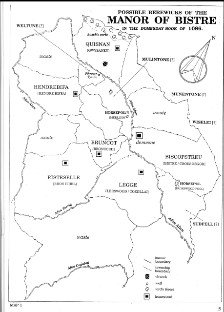
abandoment of the land during periods of hostilities. Nevertheless, Ystrad Alun or ‘Bishopstree’ as it was known to the Mercians, operated as an administrative unit based upon the principal township of Bistre and its affiliated berewicks. In fact, the whole district also bore the same name and probably covered an area coterminous with the old ecclesiastic parish of Mold. [1]
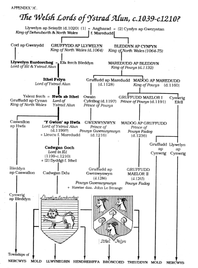
Soon after claiming the crown of Gwynedd in 1039 Gruffudd ap Llywelyn seized the lands between the rivers Conwy and the Dee, raised his standard at Rhuddlan, and according to the Domesday Book , when he visited his royal maenol in the Alun Valley his bonded subjects there were obliged to provide him and his entourage with a gwestfa ‘payment in kind’ of 1400 hesthas ‘loaves/oatmeal cakes’, seven barrels of beer and seven vessels of butter. [2] The custom was to pay such tribute at the monarch’s llys “court’ but where would it have been located? Since this occurred before the introduction of the motte-and-bailey castle to these islands the building in question is likely to have been a rectangular wooden structure of moderate dimensions [3], sited in a stategic position on the lord’s land. Positively identifying the site without archaeological evidence would be tantamount to guesswork and therefore the puzzle must remain – for the present at least – unresolved. [41 However, it would perhaps be worth bearing in mind that a residence of this description, very often accompanied by several other outbuildings, [5] was referred to in Welsh lawbooks as Tyddyn Brenhlnol ‘royal houses lead’. [6] Therefore, the most obvious place to begin one’s search would be at Tyddyn Farm in Bistre ( SJ253633 ) where a small motte stands on a piece of ground that was previosly levelled out. [7] Through displaying military strength, securing tenuous pacts and forming tactical alliences, Gruffudd managed to hold on to this north-east corner of Wales until Harold Godwinson, the future King of England, suddenly forced him to retreat westwards beyond the Conwy in 1063. He had been in possession of Ystrad Alun for a quarter of a century. On 5 August 1064 Gruffudd was assassinated by his own troops [8] and his possessions fell into the hands of his successors, Rhiwallon and Bleddyn ap Cynfyn who readily swore fealty to both earl Harold and Edward the Confessor. [9] However, it would not be long before the district was in the hands of the Normans.
It took William I nearly three years to consolidate his position in the South and Midlands of England before being forced to turn his attention to the intransigent magnates of the North in 1069. By the autumn of the following year he had quelled their feudal rebelliousness and installed his own military supporters throughout the region. Chester was placed in the hands of Gherbod the Fleming who stayed only a few months before returning to his homeland. The vacancy , now greatly enhanced by the creation of the hereditary earldom of Chester, was
conferred by the king in 1071 upon his nephew Hugh de Averanches. The extensive powers invested in this baron, together with his own agressiveness and prior experience in warfare [10] enabled him to keep both Mercian and Welsh leaders in check. He, in turn, selected one of his stalwarts, Radulph fitz Norman as Steward of Chester. This office was also to become a hereditary appointment and was to be uninteruptedly associated with Ystrad Alun until the fourteenth century. About the same time Radulph’s older brother Hugh took on the partial tenancy of the manor.
Before we embark on that story we should perhaps look at Bistre as it was described in the Domesday Book. The entries relating to this unit of local government appear under a lost “Hundred of Atiscross’ which was a territory that more or less corresponded with the major portion of pre-1974 Flintshire.
We are informed of the situation before Edward the Confessor died in 1066, that during Earl Edwin of Mercia’s occupancy, and as it was at the time of the survey in .1086, viz.,
‘Before 1066 BISTRE was a manor of ‘Earl ‘Edwin’s. It never paid tax
nor was it hidated. It was then waste, and was likewise waste when
Earl’Hugh [de Rveranche] acquired it.
Now “Hugh fitz Norman holds half of this manor from the ‘Earl,
and all of LEGGE and SUDFELL.
Land for 1 plough, which is there in lordship, with 2 smallholders.
Meadow, 1 acre.
•Value 10 s.
Odin holds the other half of the, manor from the earl
and half of MULINTONE and all of WISELEI,
Land for 1 plough, which is there with 2 slaves and 1 smallholder.
‘Value 10 s.
We can glean from this opening entry that in terms of manorial economy the estate was not functioning to its true potential. There were parts described as ‘wastes’ which probably meant they had never been turned by a plough or were derelict, either as a result of depopulation or wartime devastation. The possibility of them being occupied by the occasional Welshman who paid tribute as opposed to the Mercians’ rent or services must not be overlooked. This under-development is further emphasized by the declaration that these possessions – which are
invariably located west of Wat’s Dyke – were unhidated and therefore impossible to assess for levying geld ‘land-tax’. [11]
Although Hugh fitz Norman and Odin held most of the lands as tenants-in-chief of the Earl of Chester, the responsibility for the defence of this buffer-zone frontier is likely to have been entrusted to the earl’s cousin and lieutenant Robert of Rhuddlan. The sub-tenants’ involvement would seem to have been on a purely business-like footing. Fitz Norman is known to have resided in Sulffolk. [12]
The one plough mentioned as being ‘in lordship’ means a plough-team of four or six oxen was present on prime lands the lord had set aside for his own use in Bistre. The principal farm or demesne and was located
where the present Hill Farm stands. There were two smallholders (bordari) and one assumes the second one operated from Garreg Llwyd. Although technically freemen they were obliged to weekly spend a specified number o f man hours labouring on the lord’s property. Odin also benefited from a plough-team and had a smallholder and two slaves (serfs) to provide the service. There is no indication as to the nationality o f these tillers of the soil.
It should be no surprise to discover the area under study bore two (and later three) names. The Welsh Ystrad Alun is unquestionably the older and is descriptive of the river-meadowed valley floor of the Alun. Bistre, on the other hand, is of Anglo-Saxon origin and can perhaps be dated to the late seventh or early eighth century. Convincing victory at the Battle of Chester in 616A.D. made it possible for the Mercians to make inroads into north-east Wales by the piece-meal intaking of land along the Dee coastal strip and penetrating inland up the Alun Valley, establishing townships and manors as they proceeded. Their settlement of our district was
in all probability achieved after dioceses were established in England during the seventh century since Bistre stands for an earlier christian place-name Biscopestrev, from OE biscop’bishop’ + treow ‘tree, wooden cross’, which possibly denotes manorial ownership conferred upon an eminent ecclesiastic of that rank or is descriptive of that spot where a wooden cross once stood to indicate an open air community meeting place.[13] The area they took over appears to be a typical Welsh maenol comprising of some thirteen trefi ‘townships’ although this has yet to be established. What one could reasonably argue is that these townships pre-date Wat’s and Offa’s dykes (c.716-796A.D.), on the premise that had the earthworks been raised earlier then they would surely have been incorporated as boundaries which they clearly have not, running as they do, with the contour lines and higher ground.
Three of the four other place-names mentiond are part of an Incomplete jig-saw. That described as LEGGE has been positively identified as Leeswood [14] but what of the remainder? SUDFELL, entered with Leeswood, appears to be OE sud ‘south’ + fell<feld ‘open country’ but there is no hint as to its location.
Similarly, W1SELEI looks as though it is descriptive of a wet area, wisce ‘marshy meadow’ + leah ‘pasture’, and could be equated with modern Llong ‘marshy ground’ which abuts Bistre township and is very susceptible to flooding after heavy rains. Logic dictates the lost MULINTONE would have been somewhere one side or another of the river Alun, between Rhydygoiau and Rhyd Alun. A mylne ‘ mill ‘ was an important feature in any manor and this stretch of water has been the site of two, if not three, since the Middle Ages, all on the west
side of the river-bank. The DB makes no mention of neither mill nor a miller but to deduce that it was nonoperational at the time would probably be presuming too much; especially when one considers the amount of gwestfa payable by this manor. It simply went unrecorded. [15]
The next section of DB is sub-headed berewicks which has been translated as ‘outliers of this manor’, but since some of the places referred to are in close proximity to the home farm we should perhaps simply view them as neighbouring areas closely linked to the manor. They are as follows:
Hugh, fitz Norman holds from the earl”HENDREBIFA,
WELTUNE, MUNENTONE, the two HORSEPOOLS
and half of MULINTONE.
Land for 2 ploughs. These 2 ploughs are there
with 3 villagers and 2 smallholders.
Value 18s.
Warmund Hunter holds BRYNCOED from the ‘Earl.
Land for 1 plough.
1 villager with 1/2 plough and 2 oxen.
Value 10s.
Ralph holds RHOS ITHEL from the ‘Earl.
Land for 1 plough. It is there
with 4 smallholders.
Value 8s.
William holds GWYSANEY from the Earl.
Land for 1 plough. The plough is there
with 2 villagers and a priest.
Woodland 1 league long and & wide.
Value 10s
All this land belongs to ‘Bistre. It was waste.
It never paid tax nor was it hidated
In this manor the woodland is 1 league in length
and 1/2 league in width; there is a hawks eerie.
The Earl has this woodland, which he has put into a forest.
In this Hundred of Atis Cross
King Gruffydd had 1 manor at ‘Bistre.
He had 1 plough in lordship; his men 6 ploughs.
When the King came there himself every plough paid him
200 (loaves?), a barrel of beer and a vessel of butter
In addition to his brother Radulph, Hugh fitz Norman, [16] is also known to have had a son William. These two may well be the other landholders with Norman-bearing names mentioned in relation to Rhos Ithel and Gwysaney. This family is likely to have been conferred with the sub-tenancy of these properties as loyal retainers to Robert of Rhuddlan who spearheaded the French invasion of north-east Wales in 1073. The fourth person, Warmund the Hunter, bore a Mercian name and was possibly the forester in charge of the eerie.
Discovering Welsh place-names interspersed with English ones prompts the question as to whether Cymric and Mercian families co-existed harmoniously at this juncture, and if so, is this early proof of an embryonic Englishry / Welshry division of the manor? Ordinarily, newcomers took over the richer arable lowlands, at the same time, tolerating past-adversaries remaining on the less fertile upland slopes; land largely above 183m (600ft). [17] Such speculation has its obvious pitfalls, so also, toponomystic study. Local residents will tell you that the official interpretation of the DB form Bruncot should not be BRYNCOED as given in the orthodox translation but BRONCOED, the name of a present day electoral ward within the town.
While their identification is correct the name’s Welshness is a falacy. It’s the description of another homestead established by the Mercians, OE brun ‘brown’ + cot ‘cottage,shelter’.
Before leaving this line of enquiry it should be pointed out that the berewicks of GWYSANEY,
HENDREBIFA and RHOS ITHEL, which occur as Quisnan, Hendrebifau and Risteselle respectively in DB, have also survived a millennium and occupy the valley slopes at approximately 200m O.D. Today Rhos Ithel (SJ228607) is a small farm in Nercwys parish. Sometime between the eleventh and thirteenth century its importance obviously diminished and the township took on the designation Nercwys. Townships remained an important administrative unit right up to the nineteenth century; the Norman manor, and later the ecclesiastic parishes, basing their taxing system/poor rates on it. It would not be surprising to discover that these minor territories existed in Romano-British times, or even as far back as pre-history, but with no documentary evidence to support such a sweeping statement, we’ll have to wait for the skilled field surveyor and archaeologist to settle the matter either way.
This change in township names is found elsewhere : MUNENTONE and WELTUNE, no longer exist under those appellatives. They have been explained as containing the element tun ‘enclosure, farmstead’ and the personal name Manna and common noun well ‘spring, stream,well’.[18] I can offer no location for the former but Maes-y-Ffynnon near Bailey Hill has been suggested as ‘Wellton’ [19] although I’m inclined to identify it with Rhual township for two reasons. Firstly, Rhual does not appear as a place-name until the Late Middle Ages, and secondly, the only well of any note within Ystrad Alun is Ffynnon Rhual. Here we are once
again on difficult ground because the earliest reference to a watering-place in this township, and the only one medievally documented I might add, is to a Ffynnon Tysilio (fennon dessilio ) in 1493[20]. If it could be proven that, this commemorates St Tysilio, and that he was the original christian dedication hereabouts, then the argument is strengthened. Furthermore, this Celtic saint’s mother was named Arddun. Is it coincidence that a nearby township ( unmentioned in DB ) is called Arddunwent and the church at Hawarden was established by his cousin Deiniol? In 1086 we are told that the local priest was resident at Gwysaney, and therefore, in close proximity to this well.
Until the district’s field and boundaries have been carefully walked and its mans meticulously studied we shall never be in a position to make a categorical statement on most aspects of the local scenery as it would have been some thirty generations ago. We are probably on safe ground to speculate that the river Alun, from the Bellan downwards, was noticeably wider and more vigorous at that time and remained so for the following two or three centuries.[21] Hence, the broadening of the valley from this point downwards. Above the flood plain farming practice and land-use on the undulating and sloping terrain would have differed little from that seen in the present-day landscape; a patchwork of gweirglogddau ‘hedged-in fields’ where the stone-free ground allowed. Beyond that an open country of scrub and moorland vegetation provided rough pasture and game preserve for Earl Hugh, whom we are told, had annexed some favourable parts into his own forest. Between this open country and the hilltops was densely wooded.
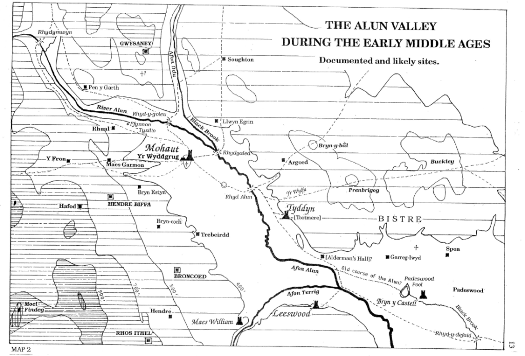
The DB entries listing very small numbers of villeins, borders and slaves points to a settlement pattern of isolated farmsteads.., smallholdings and crofts scattered on the better soils, some of which have no doubt survived into the modern era, by name if not fabric. No doubt another handful, unmentioned in the survey, eeked a pauper’s living off part of the wastes. As one historian put it, ‘betraying their presence only by the smell of woodsmoke among the trees.’ [22] The centre of activity was at the lord’s Hall, situated – I venture to suggest slightly east of the Wylfa Hill and opposite which, until quite recently, was a large field called Lord’s Meadow. If nucleated villages / hamlets existed then the first is likely to have developed at Tyddyn with the second huddled up to Yr Wyddgrug. It was a sparsely populated area supporting less than a couple of hundred inhabitants.
Before terminating with the onomastic aspect of this study, mention has to be made to the two horsepools referred to. They were certainly important enough to be singled out as topographical features without specifying the townships they were located in. I have no qualms in identifying Padeswood Pool as one of them but am hesitant to declare Trebeirdd Pond as the second because of the possibility that a field near Pentre was once a fair-sized pool (now lost) called Merllyn..[23]
The Norman offensive west of the Dee began with the new Earl of Chester establishing a castle at Hawarden c.1072 which he is likely to have entrusted to one Edard. [24] This early fortification has been identified with a small conical motte at Hawarden called Trueman’s Hill (SJ 313659). The initial strategy was to secure the territory already gained, and then with striking raids into the Clwydian heartland, put the Welsh on constant defence. Within a decade they had achieved a secondary objective of extending their newly acquired lands beyond Ystrad Alun to include Dyffryn Ial. It is debatable whether they took advantage of this opportunity to build a wooden castle to replace the caput at Tyddyn at this time. The conditions were certainly favourable for them to do so but the first direct reference to any form of habitation at this location cannot be presented for over another century.
There are several questions that require answers before we are in a position to declare when a castle, and subsequent nucleated settlement, came into being at Mold. As we have already seen the Domesday Survey of 1086 revealed the place-names within the Alun valley at that time were either Mercian or Welsh in origin. Mold is Normano-French and therefore of a later date.[25] It is inconceivable for the scribes concerned with compiling the survey’s return not to have mentioned a newly built Norman nobleman’s residence (together with any profits and perquisites) had it existed. There were certainly periods when peace reigned sufficiently-long for such undertaking, the inactivity of the north Wales dynastic rulers being particularly noticeable between 1081 and 1093. [26] We should also take notice of the fact that in the latter year Earl Hugh gifted Chester’s Benedictine abbey of St. Werburgh’s with the tithes of the Mercian border areas of Coleshill, Wepre, Hawarden and Bissopestred, demonstrating that the name Bistre was still in currency for an area greater than merely the township of that description.
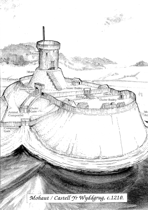
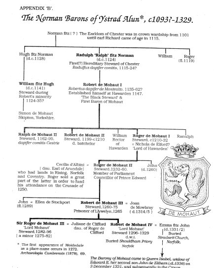
All attempts at determining when exactly a castle was first raised on Yr Wyddgrug – or elsewhere in the valley if it comes to that – have drawn a blank. However, there is ample room for conjecture. For example, the principal fortification would have to have been in situ and already bearing the French designation Monthaut ( more commonly Mohaut ) before the Fitz Norman family could embrace it as a locative surname. Our knowledge of the early members of this parvenu stock is meagre. The most prominent amongst them was Hugh fitz Norman’s brother Radulph ‘Ralph’ who was possibly the first to hold the prestigious office of dapifer ‘steward’ of Chester. Yet he died c 1124 without having displayed the surname. On Hugh’s death c1128 the family estate passed to his son and heir William fitz Hugh – and of particular significance to present thoughts – was recognised as William de Muhald prior to his death c1141. During that time Robert fitz Radulph fitz Norman had succeeded his father to the stewardship of Chester but continually witnessed charters using the patronymic naming-system, that is, until the 1150s when we find him describing himself as Robertas Dapifer Montealto.[27] Such tentative observations prompt caution. I cannot resist, however, speculating that the Mohaut surname was taken on board by at least one of these kinsmen during the period 1128-41, and no more. It certainly does not present us with proof that William built the castle. On the other hand, we can claim with some confidence that the castle’s name had been adopted by the FitzNormans prior to the baronetcy being conferred upon Robert de Mohaut I following his success at the Battle of Nantwich in 1146. It certainly pre-dates that event.[28] The Mohauts were not, as yet, lords of Hawarden.[29]
The date generally given for the establishing of a castle where the present Bailey Hill stands (SJ 235644) is 1093 although Sir J. E. Lloyd preferred a slightly later one of c.1110. [30] Unfortunately, the information available to us in this respect is paltry to say the least. Testimony from archaeology is nil and the earliest written evidence is a secondary source of the late Tudor period. The volume in question is David Powel’s The historie of Cambria, now called Wales, printed in 1584 and put together from his own studies as well as those of others. [31] Because of its tenuous nature we have long been advised to ignore it on the grounds that it is a compilation ‘unsubstantiated by documentation.’ [32]
Using Powel as their guide successive commentators have adhered rigidly to 1093 as the year the castle was raised by an obscure individual whose name otherwise does not appear in any annals, English or Welsh, of the late eleventh and early twelfth centuries. One suspects that over the last four hundred years few historians have consulted Powel’s work but merely reiterated what they had read elsewhere. Actually, the published narrative tells us very little, and perhaps, poses more questions than answers. All that appears in the marginally-dated text is a brief statement informing us that following the Normans’ successful carve-up of England a few of the kings’ most loyal supporters ( of both William the Conqueror and William Rufus ) were encouraged to acquire lands in Wales for their own benefit; estates that were to be held of them ‘by knight’s service : for which they did homage and swear fealtie’, one being ‘Eustace Cruer for Molde and Hopedale.’ And that’s it! Nothing of Cruer’s identity is known. If he ever existed then his ascent amongst the Anglo-Norman nobles was so short-lived that his achievement was only recorded the once, and that the manuscript in question was lost in private hands post- sixteenth century. We are unlikely to ever establish the truth. [33]
The fact that Powel makes reference to both ‘Molde’ and ‘Hopedale’ when both terms did not come into general use until the thirteenth and mid-fourteenth century respectively [34] is of no consequence when it is realised that they were names in common use at the time of him writing.
Looking at the eleventh century administrative situation from another perspective we discover the ancient Powys cantref of Y Rhiw comprised of three cwmwd : Hope, Ial and Ystrad Alun. When ruled by the Cymry the latter was always linked with Ial and never with Hope. Bleddyn ap Cynfyn (d.1075), king of Gwynedd and vassal to Edward the Confessor, was served on the eastern front by his trusty son-in-law and lieutenant Llywelyn Eurdorchog ‘of the golden torc’ (his symbol of authority), who was invariably referred to as Arglwydd ‘lord of’ Ial ag Ystrad Alun, so also his descendants down to his gallant great-grandson Gwion ap Hwfa (d. 1199?), known as ‘Y Gwion’. [35]. Even when Roger de Montgomery I , earl of Shrewsbury, overran Powys sometime between 1071 and 1086 he handed Ial over to the earl of Chester. [36] As one of the most powerful magnates of England it is improbable that Hugh Lupus voluntarily swopped or detached Ystrad Alun from his other lands. During the warring years 1093-99 it would have been strategically unsound to have done so. The lordship of Hope appears to have been associated with the Maelor Saesneg district until it was gifted to Dafydd ap Gruffudd following the Treaty of Conwy in 1277,[37] and subsequently incorporated in the new County of Flint in 1284.[38]
At the other end of the dating process it should be pointed out that from the Domesday Book extracts already cited no mention is made of a castle anywhere within the manor, indeed, not even of the lord’s court. Perhaps it is worth noting that the only castle referred to west of Wat’s and Offa’s dykes and north of Shrewsbury to be specifically named was the major motted keep at Rhuddlan. [39] Therefore, logic dictates that our castle is post-1086.
We should not lose sight of the fact that the great Domesday survey was not concerned with defence, but with land holding, agriculture and profits.
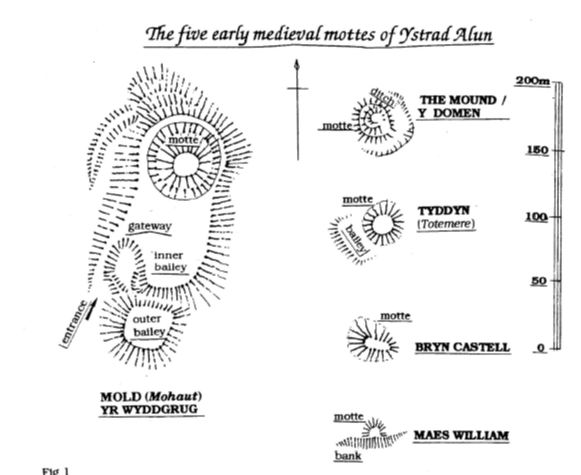
Surprisingly, Ystrad Alun boasts four other motted sites, and as was the case with the major defence upon Bailey Hill, virtually nothing is known about them.
The site of TYDDYN motte (SJ 252632) and its accompanying bailey gives the impression that it was once important enough to have been the original fortification in the Alun Valley. The only way to verify or negate this assumption would require a thorough research excavation of the site. It is equally feasible for it to be of thirteenth century construction.[40] A charter of c l l 8 5 makes no mention of it but a Totemere appears on an award of the same bounded lands in 1211, [41] allowing us to postulate that it was raised between these two dates by Llywelyn ab lorwerth after he had successfully burnt Mohaut to the ground in 1199. On the other hand, one could make a case for it to be of an earlier date because it went by a Mercian name. Totemere was a description certainly not given to it by the Welsh. It is derived from OE tot ‘to look, peep, see’ + [gejmere ‘boundary’ and can be compared with the Toothill found in Caernarfon and Rhuddlan. To strengthen our case for identification with the Tyddyn site the Welsh call the hillside hereabouts Yr Wylfa ‘lookout, watching-place’ verifying the point. However, we should not completely discount the possibility that this refers to a slight mound higher up the slope (at SJ 257635) which is certainly a better vantage point for looking up and down the valley.
Some 100m north of Leeswood Hall is THE MOUNT (SJ 252615), a large-based motte with a hint of a bailey. In 1787 the field adjacent to it was called Cae’r hen Blase ‘the old Hall’s field’, [42] implying that it was once associated with an important site. Yet, there is hardly room on the mound’s crown for it to have supported a modest-sized wooden tower. Its spiral-shaped construction certainly is not anti-personnel and I would suggest that sometime ( in the early eighteenth century perhaps?) it was modified to a ‘snail-type’ folly. It stands on the opposite side of the valley to Bryn Castell. In fact, we find three castles in a more or less straight line here, [Map 2.] guarding the approach from England – intimating that they were Welsh bastions of defence.
Lower down the valley, near to Padeswood Pool, is BRYN CASTELL (SJ 281619). Its position allowed lookouts to observe hostile groups emerging out of the extensive forest that separated the lordships of Mold and Hawarden, and at the same time, look further down the dale since it diverts in a south-easterly direction at this point. Its previous name of ‘Bryn Grono’ [43] suggesting its original or last occupier was a local noble called Grono/Goronwy, a common enough Welsh masculine forename in the Middle Ages.
Nothing is known of MAES WILLIAM (SJ 245612) other than it guarded the narrow defile created by Afon Terrig.
Our present knowledge does not permit us to say whether any of the five mottes were contemporaneous nor who built them.
When Maud, daughter of the deceased Henry I, made her bid for King Stephen’s throne in 1136 Earl Ranulph I of Chester allied himself to her cause as she was for maintaining the tight feudal control of the country as established by the Conqueror, and at the same time, allowing the earls to be more or less independent of royal authority. Her success resulted in Ranulph often being absent from his earldom, the defence of which he entrusted to the reliable Robert de Mohaut I. The latter’s uncompromising methods of achieving his aims earned him the nick-name ‘The Black Steward.’
In late August of 1146 the Welsh of the border country, taking advantage of the fact that Stephen had imprisoned Ranulph I , and that the princes of Gwynedd were militarily involved in south-west Wales, went on the offensive, cutting-off the Normans’ outpost in Ystrad Alun from its reserve base at Hawarden. Within five days the men of Powys under their leader Madog ap Maredudd had succeeded in ravaging the borderlands and capturing Oswestry. Robert de Mohaut I retaliated promptly by advancing southwards, defeating the Powysians in an extremely bloody battle near Nantwich. [44] The Welsh chronicles mention the fall of castell Yr Wydguc at this time but the latest research identifies this with another motted site named Gwyddgrug in Carmarthenshire. [45]
The ensuing years saw the political situation between the houses of Gwynedd, Powys and the earldom of Chester deteriorate rapidly. In 1149 Owain Gwynedd upset the others by raising a castle at Tomen y Rhodwydd not far from Llandegla. The following year saw the other two factions responding by joining forces and
marching into Tegeingl where they were promptly checked and defeated at Coleshill near Flint, and when Henry II rashly intervened in 1157 he was ambushed in Coed Pennarddalaog ‘Hawarden Wood’, narrowly escaping with his life. The stalemate that ensued saw Owain prudently acknowledge the Crown’s overlordship and was consequently obliged to relinquish his hold on Ystrad Alun by withdrawing west of the Clwyd. Robert de Mohaut I must have been overjoyed at this surprising outcome after being denied his lands for over a decade.
However, he died in 1159 and two years later Owain broke the king’s truce but no mention is made of him reclaiming our particular area. In 1164 Henry I I made a brief, and last, incursion into north-east Wales in an effort to finally subdue the Welsh prince but his route via the Berwyn Mountains took him in a direction away from Ystrad Alun. It is only in 1166, after the king had departed for France, that we have our positive evidence of Ovvain re-occupying the Alun Valley. He died in 1170, his lands east of the Conwy going to his son Dafydd who, when paying homage to Henry II at Oxford in 1177, returned them into royal hands. Radulph de Mohaut II promptly re-established himself at Ystrad Alun.
Twenty years of peace was shattered on 6 January 1199 when Llywelyn ab Iorwerth, hitherto embroiled in internal wrangling within Gwynedd, crossed the Clwydian Hills and took the castle at Mohaut [46] but not without the Normans putting up a fierce resistance. According to the poet Cynddelw Brydydd Mawr (cll55- 1200) the river Alun ran red with blood, [47] and elsewhere we are told the fortification was heavily damaged if not destroyed. [48] Llywelyn’s court bard Llywarch ap Llywelyn (c 1150-1220) proudly informs us that it was a complete victory, involving a great fire, with the local inhabitants fleeing in panic. Interestingly, he makes
reference to more than one tower : Tyreu poeth, peithiawc pob un ‘Burnt towers, destroyed every one’ [49] which perhaps relates to gatehouses in addition to the principal tower raised upon the motte. Robert de Mohaut II (d.1210) automatically took over the stewardship on the death of his brother in 1199, but now, regrettably, could only gaze down at the splendour of the vale below from nearby Buckley, which lay within his lordship of Hawarden and which he still held.
Llywelyn’s diplomatic skills allowed him to retain his acquisition after paying homage to King John in1201 but over the next decade his growing power and escalating brinkmanship – despite having married John’s illegitimate daughter Joan – forced the king, in 1211, to lead an army (accompanied by a host of Powysians under Gwenwynwyn) into north Wales. And as had been the practice amongst previous rulers of Gwynedd, Llywelyn sought refuge in Snowdonia. [50] He was, however, astute enough to realise his futile position and relinquished his claim to the region between the Conwy and the Dee resulting in the immediate occupancy of Ystrad Alun by the previous steward’s brother Roger de Mohaut I.
A common cause can make strange bed-fellows and it was not long before Llywelyn found himself allied to earl Ranulph III of Chester and other prominent members of England’s baronage against the avaricious and unappeasable John. The situation was brought to a head in June 1215 when the king reluctantly signed the Magna Carta, reinstating their lands to dispossessed Welshmen. Llywelyn’s position within the principality was further strengthened when his vassals re-acknowledged his overlordship at Aberdyfi in early 1216. His old rival Gwenwynwyn then played into his hands by defecting to John’s side and a prompt military offensive on Llywelyn’s part not only saw him annex Powys Gwenwynwyn to his territories, but also, drive his adversary into permanent exile beyond Offa’s Dyke. [51] Furthermore, a poem in praise of Llywelyn by his court bard upon the trimphant outcome of this particular offensive acclaimed his ‘winning of Hawarden’ (Cefaistelfydden Alaawg ) and that the frontier territory was in a state of desolation. [52]
John’s death in October 1216 brought a minor to the throne, nine year old Henry III . Like many of the English barons Llywelyn took advantage of the situation by nonchalantly extending his princedom. However, it was a short-term insurgence hurriedly concluded in 1218 with the Treaty of Worcester, the terms allowing Llywelyn to retain his recently gained territories on pledging homage and armistice. Likewise, he and earl Ranulph III of Chester came to an amicable agreement over his occupancy of Mohaut and Ystrad Alun, doubtless to the utter dismay of Roger de Mohaut I (d. 1232) who would never again tread the lush grass of the Alun valley. He was succeeded by his eldest son of the same name who became at various times : Justice of Chester, Member of Parliament and counsellor to both the king and ‘The Lord Edward’. Despite the earldom being conferred upon the prince in 1237 ( after earl John le Scot had died without issue ) Roger de Mohaut II (d.1260) kept his hereditary stewardship and remained to his compatriots as the acknowledged Baron of Mohaut. However, it would be a few years yet before he first set foot in Ystrad Alun to practise his seigneural rights.
His opportunity came with the death of Llywelyn ab Iorwerth on 11 April 1240. He immediately
petitioned Henry III for the restoration of his family lands in Ystrad Alun. The king responded in a noncommital and swift manner by appointing two marcher lords to impartially seek evidence as to the pretentions of the De Mohauts and Llywelyn’s heir, Dafydd ap Llywelyn. Meanwhile, on 15 May 1241, Dafydd paid tribute to his uncle Henry I I I , [53] while he in return acknowledged the prince’s claim to Gwynedd,[54] but there remained a great deal of animosity amongst the Anglo-Norman barons regarding the north Wales territories they had been forced to yield over the past forty years. Henry III was not enamoured by the thought of a continuation of the status quo either, and his excuse for raising a force to subjugate his adversary presented itself in mid-June of that year when Dafydd failed to appear at the arbitration council’s hearing.
Early in August the king ordered his chief administrator at Chester, John le Strange, to cut a passage through the woods ahead of the main force to prevent ambushing, and also, instructed him to retake and hold Ystrad Alun.[55] Dafydd’s capitulation was almost instantaneous and in signing the Treaty of Gwerneigron (29 September), [56] promised to vacate and relinquish his claim to his possessions east of the Conwy. The clause that concerns us reads
I also promise that I will hand back and surrender to him [the king], or to whom he should command, all the land of Muhaul, and its appurtenances, and the
seisin (seisinas ) of Roger de Muhaut, Steward of Chester, and all of the other
barons and faithful men of the same lord king, occupied from the time of war
arising between our lord King John and Llywelyn my father….’ [57]
Within a month Dafydd made yet a further concession. The settlement for Ystrad Alun thus reading :
‘I have also surrendered the land of Muhant to my same lord the king, just as I had
promised him previously And if he wishes to keep the same in his hands, then,
in accordance with his will, he may keep the same, without any claim of me or my
heirs.’ [58]
Since time was to lapse before the king handed the lordship over to Roger de Mohaut II he may well have had other plans for the fortification. Perhaps he sensed that Dafydd was not a man of his word, who knows? One thing is certain, at the end of October John le Strange was directed to immediately spend £40 on repairing the castle with money raised from lands under his charge to make the outpost defendable. His instructions were to ‘repair all that requires repair in the king’s castle.’ [59] Adding insult to injury, Dafydd ap Llywelyn was also to be charged £200 in order that certain royal strongholds in north Wales, Mohaut amongst them, could be made secure.[ 60] At this stage, at least, it does not appear that Henry III had any intention of complying with Roger de Mohaut II’s request because when he did oblige his Hawarden-based baron, it was as a royal constable or custodian that the appointment was made on 6 May 1242. [61] He does, however, appear to have promised him a vanguard position in any future offensive should Dafydd break truce, and two years later, on 24 May 1244, Roger II was conferred as the castle’s holder. [62]
Intelligence received in early March 1245 told of growing unrest amongst the Welsh princes and that ‘engines’ were being constructed for the beseiging of either Diserth or Mohaut.[63] The king promptly ordered John Le Strange to raise Serjeants, both mounted and on foot, to resist the pending siege [64] but his efforts were to no avail as within three days ( on 28 March ), and without mercy, Dafydd took the stronghold :
‘Then the well-known Dafydd, with his followers seized ( occupavit) the castle which is called Munthaut, and, slaughtering those whom he found there, levelling it to the ground.’ [65]
As expected, the ‘Annales Cestriensis’ ( or the ‘Chronicle of St. Werburgh’ as it is sometimes referred to ), was written from the standpoint of the local Anglo-Normans, and is less explicit. We are simply told that the castle fell after a siege, [66] while the contemporary Benedictine monk Matthew Paris provides a more graphic description:
‘But Dafydd, undertaking it himself, with his followers besieging Munthaut with a siege camp, violently seized the same within a short space of time, and, slaughtering those whom he found, or carrying them off with him, gained the victory as he had vowed. However, the lord of that castle, namely Roger de Munthaut, who was not found in the castle, strove against him more cautiously in that district
The feuding continued:
Thereafter, there accordingly arose a very bloody war. Nor did they spare one party or another, on this side or that, because of their sex, age or condition, they gathered all the people together to eliminate them.’ [67]
Henry Ill’s army of retaliation devastated all in its wake but failed to force Dafydd into submission. Severe weather compelled the enraged king to withdraw completely from Snowdonia, vowing to return in the following spring. This was not to be as Dafydd ap Llywelyn died childless on 25 February 1246. Not for a century had the Crown’s position been stronger in Wales. Within no time the independant princelings reluctantly acknowledged Henry Ill’s overlordship, amongst them in early 1247, Llywelyn ap Gruffudd and Owain Goch ap Gruffudd, grandsons of Llywelyn ab Iorwerth who now shared power in Gwynedd.
The Treaty of Woodstock (30 April 1247) saw Llywelyn and Owain jointly sign away any rivileges or pretentions they might have had to the land between Conwy and Dee. The cantrefi of Dyffryn Clvvyd, Rhos & Rhufoniog, Tegeingl, and the cwmwd of Ystrad Alun were quit-claimed to the king who was at liberty to dispose of them at will. Of Ystrad Alun it was said :
and all the land of Monte Alto, with their appurtenances, without any reservation, so that neither the same Owain and Llywelyn nor their heirs shall have, or shall be able to have, any right or claim in the same cantrefi or in the land of Monte Alto, or in their appurtenances. [68]
Roger de Mohaut I I needed no encouragement to seize his opportunity !
Copyright of articles
published in Ystrad Alun lies with the Mold Civic Society and individual contributors.
Contents and opinions expressed therein
remains the responsibility of individual authors.