By John Cole M.A. FSA scot
King’s paradox of castle building, that danger inspired castle building, but they could only be built strongly in conditions of peace, forms a provocative introduction to the study of early castles in marginal territories.
It is of course an over simplification, although a glance at the often published distribution maps might appear to confirm it. The presence of 319 motte and bailey or ring work castles might imply that chronic insecurity had dictated the proliferation of small, primitive and hurriedly raised fortifications. This view has been questioned of late.
At Hen Domen it was possible to demonstrate that a whole series of timber and clay fortresses had dominated the landscape for over two centuries, backed up by a number of much smaller castles in the Vale of Montgomery argued to form “a perfectly homogenous group, just what one would expect if one of the Earls had decided to settle his waste land with peasantry and small military tenants”.
Largely dependent on local resources of not only timber but also clay and easily available stone and lime, the lesser tenant was likely to employ all in a variety of combinations.
At Symon’s Castle a mound of burnt clay and soil over lying three large beam slots indicated the presence of a tower, its fourth side comprising footings of a stone – faced curtain wall into which the timbers had been tied. Within the enclosure a concentration of burnt daub with impressions of straw, wood, and overlapping planks, in association with
nearly 700 nails implied the existence of a hall akin to the garden shed style of construction.
In Mottes and Moated Sites Spurgeon summarized 35 early castles in Clwyd, most comprising mottes with or without baileys, the majority formed by reshaping prominent glacial features.
The middle Alun Valley contains five, of which Bailey Hill is unique in possessing in fact two baileys, and is clearly the largest and most powerful of the group. There is little of the uniformity of style recognized in the vale of Montgomery, but their geographical distribution may be significant.
Lees Wood stands in visual communication with Maes William on the other side of the little River Terrig, while Bryn y Castell is some two kilometres to the east among the bunds and bunkers of the Padeswood golf course. All had been sited on the west bank of the Alun.
Lands east of the river had long been waste, and the de Mohaut grant of lands at Spon listed unlimited right of assart in the forests of Bistre and Swerdwode. In 1185 one boundary marker was named as Aldermoneshale, which by 1220 had become Totemere, which appears to imply the repair or foundation at this date of our remaining castle, the purposeful motte and bailey at Tyddyn, high above the river with a
clear view to Mold. Whether its position represents a tactical withdrawal is uncertain, although 1199 had been a particularly bad year for the lords of Mold.
Now a public park of sorts, Bailey hill as been ransacked, re-graded, lawned and increasingly ignored, while the notes made by successive antiquaries have been dismissively brief and of dubious accuracy.
In 1849, during operations to lower and level the surface of the bailey to produce a bowling green, a number of human skeletons was uncovered at a depth of some two feet, regularly orientated, some with their skulls detached.
In 1872, a brief note of more speculative excavations related the discovery of two parallel stone walls four foot and eight and a half feet thick and ten feet apart at the west foot of the mound. These were rediscovered in 1891, when ” some of the scavengers of the town were put to work on the summit of the hill” where at a depth of four feet they
uncovered a large quantity of stone, together with a wall and part of a circle, after which they seemed to have returned to the previous location, where the same parallel walls were now recorded as six and ten feet in thickness and some four yards apart. The correspondent reported that these ” are supposed to be an entrance to a tower embedded in the soil.”
Such is almost the entire archaeological record for this large imposing and long suffering monument.
The prominent ridge occupied by the castle lies north – south, strengthened by scarping and ditching to increase its isolation. It commands the entire vale, which constitutes some of the best agricultural land in Flintshire, and the most useful crossings of the Alun
at Colleyford and Pentre almost beneath it to the east.
The lower outer bailey, D shaped and twenty by thirty metres, covered the only approach and probably functioned as a barbican. Such enclosures often retained timber defences long after the more important middle or upper baileys had been walled in stone.
The motte was raised on the highest and widest part of the ridge and a small much lower spur cut off to the north. It has been suggested, on the evidence of the welsh place name, Yr Wyddgrug, that a prehistoric tumulus might lie at its heart, and certainly the Normans were no respecters of the past when military expediency prevailed, as the
certain examples at Rug and Whitchurch, Cardiff, attest.
Calculations employed by King and Spurgeon suggest that with a height of six metres the base diameter should total about 36 metres, the summit being now about 18 metres. As it measures almost sixty metres this might indicate unstable subsoil or a deliberate levelling.
In practice, such formulae are often of little use. At Goltho the motte was shuttered in vertical timbering, producing an effect which can be seen today at Berkeley.
The summit of the motte is now greatly disturbed. The extensive root system of the trees may have contributed to the loss of material, but it should be recalled that the spoil of 1891 had to go away from the bowling green, and the northern profile of the motte shows a noticeable slip and bulge at its base. Here too, exposed by unrepaired erosion are two arcs of slabby masonry, perhaps the wall and part of the circle uncovered. Released from confinement a mass of material has partly obscured the line of a ditch cutting off the northern spur now occupied only by the Eisteddfod stone circle.
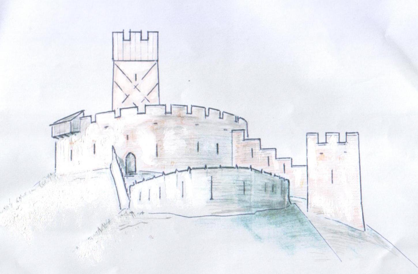
If we seek a date for the construction of stone defences at Mold, the stylistic elements have to be related to the history of the de Mohaut’s possession of the lordship. The stone forebuilding and shell keep at the royal castle of Pickering have been dated towards the end of their longest uncontested tenure. It is possible that the tower some twenty eight feet square at the foot of the mote dates from the closing years of the 12th century;
Perhaps also the stone circuit upon its summit. If so. both are likely to have bee”, reduced by Llewelyn ap lorwerth in 1199, and any rebuilding undertaken in some haste in the 1240s .
The accompanying illustration can be little more then an informed guess at what might have been raised by Rodger de Mohaut II as he prepared to face the resurgent power of Gwynedd.
Copyright of articles
published in Ystrad Alun lies with the Mold Civic Society and individual contributors.
Contents and opinions expressed therein
remains the responsibility of individual authors.